A Station Calculator is a surveying calculator that determines the location of a new point from a known reference station. It uses measured field observations such as slope distance, zenith angle, and horizontal angle to calculate northing, easting, elevation, horizontal distance, and vertical distance.
Surveyors often collect these measurements using total stations and other advanced surveying instruments. The calculator processes the collected data through trigonometric formulas and generates accurate coordinates for the target point. As a result, users can efficiently establish control points, map terrain, verify construction layouts, and maintain alignment accuracy throughout engineering projects.
Detailed Explanation of the Calculator’s Working
The Station Calculator operates by converting measured distances and angles into coordinate changes. First, the surveyor inputs the known station coordinates, slope distance, zenith angle, and horizontal angle.
Next, the calculator computes the north-south movement (Delta N), east-west movement (Delta E), and elevation difference (Delta Elev). These values represent how far the new point lies from the known station in each direction.
Afterward, the calculator adds these coordinate changes to the original station coordinates. Consequently, it generates the new northing, easting, and elevation values.
Additionally, the calculator determines horizontal distance and vertical distance, allowing engineers to evaluate both ground positioning and height variations. This process significantly improves surveying efficiency and measurement accuracy.
Formula with Variables Description
Formula

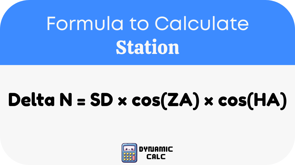
Delta E = SD × cos(ZA) × sin(HA)
Delta Elev = SD × sin(ZA)
New Northing = Known Northing + Delta N
New Easting = Known Easting + Delta E
New Elevation = Known Elevation + Delta Elev
Horizontal Distance (HD) = SD × sin(ZA)
Vertical Distance (VD) = SD × cos(ZA)
Variable Descriptions
| Variable | Description |
|---|---|
| SD | Slope Distance between known station and target point |
| ZA | Zenith Angle measured from the vertical reference |
| HA | Horizontal Angle measured in the horizontal plane |
| Delta N | Change in Northing coordinate |
| Delta E | Change in Easting coordinate |
| Delta Elev | Change in Elevation |
| HD | Horizontal Distance |
| VD | Vertical Distance |
| Known Northing | Existing North coordinate |
| Known Easting | Existing East coordinate |
| Known Elevation | Existing elevation value |
| New Northing | Calculated North coordinate |
| New Easting | Calculated East coordinate |
| New Elevation | Calculated elevation value |
Common Surveying Reference Values Table
The following table provides commonly used angle conversions and surveying references.
| Degrees | Radians | Percent Grade |
|---|---|---|
| 0° | 0.0000 | 0% |
| 5° | 0.0873 | 8.75% |
| 10° | 0.1745 | 17.63% |
| 15° | 0.2618 | 26.79% |
| 20° | 0.3491 | 36.40% |
| 25° | 0.4363 | 46.63% |
| 30° | 0.5236 | 57.74% |
| 35° | 0.6109 | 70.02% |
| 40° | 0.6981 | 83.91% |
| 45° | 0.7854 | 100.00% |
| 50° | 0.8727 | 119.18% |
| 60° | 1.0472 | 173.21% |
Common Distance Conversions
| Unit | Equivalent |
|---|---|
| 1 meter | 3.28084 feet |
| 10 meters | 32.8084 feet |
| 100 meters | 328.084 feet |
| 1 kilometer | 1000 meters |
| 1 foot | 0.3048 meters |
| 1 mile | 5280 feet |
| 1 mile | 1.60934 kilometers |
Example
Suppose a surveyor has the following measurements:
- Known Northing = 1000 m
- Known Easting = 500 m
- Known Elevation = 120 m
- Slope Distance (SD) = 100 m
- Zenith Angle (ZA) = 30°
- Horizontal Angle (HA) = 45°
Step 1: Calculate Coordinate Changes
Delta N = 100 × cos(30°) × cos(45°)
Delta E = 100 × cos(30°) × sin(45°)
Delta Elev = 100 × sin(30°)
Step 2: Calculate Results
Delta N ≈ 61.24 m
Delta E ≈ 61.24 m
Delta Elev = 50.00 m
Step 3: Determine New Coordinates
New Northing = 1000 + 61.24 = 1061.24 m
New Easting = 500 + 61.24 = 561.24 m
New Elevation = 120 + 50 = 170.00 m
The calculator quickly produces accurate coordinates without requiring lengthy manual calculations.
Applications
Land Surveying
Surveyors use Station Calculators to establish control points, determine property boundaries, and create topographic maps. Accurate coordinate calculations help ensure that survey data remains reliable throughout the project lifecycle. Consequently, surveying teams can produce precise land measurements and legal boundary documentation.
Construction Layout
Construction professionals rely on Station Calculators when positioning buildings, roads, bridges, utilities, and structural components. By calculating exact point locations, engineers can transfer design plans from digital models to real-world construction sites. This process minimizes alignment errors and improves overall project accuracy.
Infrastructure and Transportation Projects
Roadways, railways, pipelines, and utility corridors require precise positioning data. Station Calculators assist engineers in determining station locations, elevation changes, and alignment points. As a result, infrastructure projects achieve better accuracy, improved safety, and more efficient construction workflows.
Most Common FAQs
What is a Station Calculator used for?
A Station Calculator is primarily used in surveying and civil engineering to determine the coordinates and elevation of a new point based on known reference data. It processes measurements such as slope distance, zenith angle, and horizontal angle to calculate northing, easting, elevation, horizontal distance, and vertical distance. Professionals use it for land surveys, construction layout, mapping, and infrastructure development where positional accuracy is critical.
Why is slope distance important in station calculations?
Slope distance represents the actual measured distance between two points along the line of sight. Since terrain often contains elevation differences, the slope distance differs from horizontal distance. The calculator uses slope distance together with measured angles to determine accurate coordinate shifts and elevation changes. Without slope distance, surveyors would struggle to accurately locate points on uneven ground.
What is the difference between horizontal distance and slope distance?
Slope distance measures the direct line between two points, including elevation changes. In contrast, horizontal distance measures the projection of that line onto a horizontal plane. Surveyors frequently require horizontal distance for mapping and design purposes because it reflects the true ground position relative to other coordinates. Station Calculators automatically derive horizontal distance from slope distance and angle measurements.